Cronton Church of England Primary Academy Believe Enjoy Succeed Together
Geography
![]()
At Cronton CE Primary School our KEYS Curriculum is built around the National Curriculum, enriched to reflect the children and community we teach in. As a church school our Christian ethos and school values are the heart of everything we do.
We believe every child can be their BEST with our Vision statement reflecting this.
“I can do everything through God who gives me strength” Philippians 4:13
![]()
![]()
How Geography Links with Our KEYS Curriculum
Our curriculum plan sets out the aims of Geography and assures a full coverage of the National Curriculum while challenging the pupils and inspiring their curiosity!
Geography is a living, dynamic and relevant subject. It is so much more than just memorising place on a map! Our Cronton CE Curriculum KEYS – Knowledge and Skills Empower You to Succeed captures exactly what study of geography is: offering a uniquely powerful view of the world which prepares our pupils for successful future. In order to become global citizens, the children have an opportunity to grasp how the world works and how they fit into it.
Michael Palin said, “Geography is the subject which holds the key to our future.”
Building on their observations of the world in Early Years, the children in Cronton CE Primary develop their sense of place, location and scale. Through knowledge and skills, they gain a better understanding of our world. Furthermore, by the end of Year 6, they are well-equipped to fathom the big global issues and start exploring possible solutions.
If you would like to get involved with Geography at Cronton CE (maybe you visited exciting places? You are a cartographer? You work in import-export? You did the Three Peaks Challenge?), please do not hesitate to contact the school.
#geographyobsessed
Recently, we have gained the 'Primary Geography Quality Primary Mark' in Bronze which is a prestigious award that recognises and promotes quality and progress in geography leadership, curriculum development and learning and teaching in schools. This is something that we are truly proud of at Cronton CE.
![]()
Key attributes of a geographer at Cronton
- A curiosity and fascination for the world around them
- Have a deep understanding of the world’s physical features and processes
- Have knowledge of the planet’s significant places and be able to make comparisons between them.
- Be able to collect and interpret a range of data from the world around them
- Be able to make connections between the physical and human features of our planet to other areas of the curriculum
Intent
The intention of our Geography curriculum is to develop a knowledge, skills and understanding of key geographical concepts through the study of significant geographical topics. Geography should inspire pupils’ inquisitiveness, curiosity and through the study of human and physical features, prepare them to become global citizens; aware of our changing world.
By developing contextual knowledge of the location of globally significant places and understanding the processes that shape our diverse settings and societies, the children will be equipped to recognise the significance of the change over time and spatial awareness.
The pupils will be taught how to collect, analyse and present data during their fieldwork opportunities and they will practice their maps skills by a use of a variety of atlases, maps and online resources.
![]()
Implementation
Our Cronton Geography Curriculum has been designed in order to achieve full National Curriculum coverage and allow clear progression of knowledge and skills from EYFS to subsequently KS3 by creating diagonal, horizontal and vertical links, which allow opportunities for the pupils to revisit and build upon their previous learning hence altering their long term memory.
![]()
Lesson Structure
Geography lessons have a set format (apart from Fieldwork lessons) that has to be followed to maintain consistency, progression and allow for all the knowledge and skills being implemented.
This lesson structure has been designed to ensure the children learn more and remember, combining recapping with learning new knowledge and allowing children to make links. They will develop an understanding of geographical vocabulary and knowledge. They will be able to use geographical skills to learn about the world around them and be able to present their knowledge and findings in a variety of ways.
![]()
![]()


Geography Overview
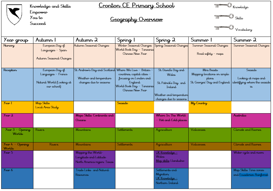
Our curriculum will be changing in the next few years. We have had the exciting opportunity to phase in and implement our new curriculum which is called 'Opening Worlds'. This has been designed by Christine Counsell and Steve Mastin to boost literacy and academic achievement within the humanities subjects. It focuses on embedding different teaching techniques within lessons, such as: vocabulary acquisition, storytelling, retrieval practice and active participation. The children will study Geography every week instead of every other half term.
Below you can read the Opening World's plan and rationale:
Sequencing and End Points
Overview of topics for each year group
EYFS
Children learn about other countries: France (European Day of Languages), Tanzania (World Book Day/Reading Week) and the countries that make up the UK when learning about the patron saints and celebrating their special days. They locate them on world maps and globes and discuss main features e.g. size, capital city, climate and differences in life styles at a basic level. They also explore more about Britain when we undertake a mini project on the country. They look at maps and atlases which are out in the provision. They can talk about differences between where they live and other areas in simple terms.
Year 1
Autumn: Map skills: Our School
In this unit, the pupils will continue developing their understanding of the World from EYFS and their locational knowledge through first-hand observation and use of basic specific vocabulary.
This unit is highly practical and allows the children to explore the geographical properties of their known environment (school) and some of the features present. The pupils will learn that sizes and locations can be mapped in plans and identified using aerial imagery and that the school has different areas with specific layouts and designated activity.
The children will begin to expand their knowledge by talking about the journey from their homes to the school and they will build on this in Year 2 when making comparison with a school in Australia.
Spring: Seaside
Seaside is a unit of work which takes the children’s previously learned map skills and experience of fieldwork and extends it beyond the local area while still drawing on their understanding of the world and life experiences.
The children will be learning about the unique nature of Britain as an island and the surrounding seas by looking at maps. This will prepare them for learning more about their country in Summer 1 Unit My Country as they will get increasingly familiarised with the outline shape of the UK.
Through the use of maps, pictures, photographs and aerial photographs, the pupils will be taught to recognise both physical and human features of the seaside regions and the importance of coastline both for recreation and habitat for fauna and flora that needs protecting.
The children will be able to revisit their learning during History topic and the role coastline defence played in the last successful invasion of Britain by William the Conqueror. In Summer 1, they will develop their knowledge of the UK further.
Summer: My Country
In this unit, the pupils’ understanding of the UK and their local area will be developed and they will be allowed to make valuable links between their own experiences (trips, news) and ways of recording location on a map.
Serving as a short introduction, the children will begin to understand what makes each of the 4 countries of the UK special and this will be later on developed in the KS2 UK knowledge studies.
Discussing what makes our country special and unique and some of the symbols associated with it will allow the pupils to start building a deeper understanding of some of the attributes of countries and prepare them for Year 3 unit of work UK as a part of Europe.
Year 2
Autumn: Continents and Oceans
Building on their knowledge of the UK and local area from Year 1, the pupils will embark on a learning journey leading to their understanding of our planet Earth. They will begin to ask and answer questions about how people find out information about the planet. Through observation, work with maps and atlases and globes, they will be developing the global geographical context of their homes and environments. It will serve as an introduction to the geographical concepts of place and space and it will also allow the children to start thinking about scale.
This unit of work should inspire the children to want to explore the Earth and its uniqueness further and set solid foundations for their further learning about hot and cold places and Year 2 and finally, allowing them to contract their locality with a non-European country (Australia). Furthermore, their growing understanding of Earth will prepare them for more in-depth learning about each continent in KS2 and the interaction between human and physical processes in Year 6 topics Trade and Migration.
Spring: Hot and Cold places
Following their learning of Continents and oceans, the pupils will further develop their map skills and knowledge by locating the poles, the Equator and the human and physical features of different regions. They will be contrasting and comparing this with their understanding of the seasons from Year 1.
Their investigation of plants of different regions will be deepened in Summer 1 Science study of plants and they will research the desert region of Australia in Summer 2.
The children will get a chance to revisit and further develop their knowledge by studying Biomes and Climate zones in Year 4.
Summer: Australia
Following their study of our planet and some of the hot and cold places on Earth, the pupils will conclude this year’s learning and develop their world locational knowledge through studying the country of Australia and comparing the region of Thursday Island with the Widnes area.
After locating Australia on the globe and suggesting routes there from the UK, the children will have a chance of observing the differences and similarities between the two countries and understanding the historical link between them. They will deepen their knowledge of the physical and human features of Australia and the uniqueness of its nature and wildlife. In Year 4, this will be developed through the unit Biomes and Climate zones. A close investigation of the process of making some of the Australian products will lay the foundations for Year 6 study of Trade links.
Finally, the children will be able to learn about the Thursday Island, one of the Torres Strait Island and comparing its culture and way of life to their own.
Year 3
Year 3 have had the exciting opportunity to implement our new curriculum which is called 'Opening Worlds'. This has been designed by Christine Counsell and Steve Mastin to boost literacy and academic achievement within the humanities subjects. It focuses on embedding different teaching techniques within lessons, such as: vocabulary acquisition, storytelling, retrieval practice and active participation.
Year 3 Units:
Rivers
Pupils learn about the key features of rivers, how they are formed, and their importance to people. They explore how rivers influence settlements, transport, and land use.
Mountains
Children study mountain landscapes, learning how mountains are formed, where they are located and how they affect climate, wildlife, and human activity.
Settlements
This unit explores different types of settlements, from villages to cities. Pupils learn why settlements develop in certain locations and how physical and human features influence where people live.
Agriculture
Pupils investigate how land is used for farming. They learn about different types of agriculture, the crops and animals produced and how farming varies depending on the climate and landscape.
Volcanoes
Children are introduced to volcanoes, learning how they are formed, where they are found and how volcanic activity can both create and destroy landscapes.
Biomes
This unit explores the world’s major biomes, such as deserts, rainforests, grasslands and tundra. Pupils learn how climate influences vegetation, wildlife, and human life in each biome.
Year 4
Year 4 have had the exciting opportunity to implement our new curriculum which is called 'Opening Worlds'. This has been designed by Christine Counsell and Steve Mastin to boost literacy and academic achievement within the humanities subjects. It focuses on embedding different teaching techniques within lessons, such as: vocabulary acquisition, storytelling, retrieval practice and active participation.
Due to this curriculum being phased into year groups, both classes start off with the year 3 units:
Rivers
Pupils learn about the key features of rivers, how they are formed, and their importance to people. They explore how rivers influence settlements, transport and land use.
Mountains
Children study mountain landscapes, learning how mountains are formed, where they are located and how they affect climate, wildlife, and human activity.
Settlements
This unit explores different types of settlements, from villages to cities. Pupils learn why settlements develop in certain locations and how physical and human features influence where people live.
Agriculture
Pupils investigate how land is used for farming. They learn about different types of agriculture, the crops and animals produced and how farming varies depending on the climate and landscape.
Volcanoes
Children are introduced to volcanoes, learning how they are formed, where they are found and how volcanic activity can both create and destroy landscapes.
Biomes
This unit explores the world’s major biomes, such as deserts, rainforests, grasslands and tundra. Pupils learn how climate influences vegetation, wildlife, and human life in each biome.
Year 5
Autumn: Mapping the World – longitude and Latitude
North America region – Texas
Continuing to deepen their knowledge and understanding of our world, the pupils will be investigating why and how is our Earth mapped. After having gained insight into the link between climate zones and lines of latitude, the children will be practising their map skills using atlases and maps to locate countries and basic coordinates. Building upon their knowledge of Continents and Oceans from Year 2, the pupils will then move onto the study of a region in North America: Texas. They will be able to revisit their learning of Biomes from Year 4 through careful investigation of Texas’ biomes and will be making comparisons to their own locality and its human and physical features.
This unit serves as a consolidation of some of the key geographical concepts that the pupils learn in KS1 and LKS2 and at the same time allows the children to begin gaining understanding into how are continents and countries connected, which they will develop in Year 6 when looking at Trade links and Settlements and Migration.
Spring: UK Knowledge: Wales and Map Skills: Llandudno
This unit of work builds on the pupils’ previous knowledge from KS1 of UK’s four countries and the Seaside unit in Year 1 by extending further their knowledge of coastlines and how are coastlines formed. Continuing their learning of the UK’s locational knowledge from Year 3 (Scotland) and Year 4 (England), they will research in more depth Wales. This will allow them to prepare for their residential trip to Llandudno as a seaside resort and coastal town and while there, using fieldwork and map skills to make sketches, create maps and recognise human and physical features as identified on OS maps. In use will be put the pupils’ previously obtained skills and knowledge of land use patterns from Year.
This unit will also serve well as a comparison to previously studied region in North America (Texas) in Autumn in relations to habitats and biomes.
By learning about the human and physical features of Wales and what makes it special, the pupils will get a deeper understanding of some of the historical changes linked to the country and its industry and research of the Dinorwig power station provides a link to environmental science and natural resources unit in Year 6. Finally, a year later, the children will conclude their learning of the 4 countries of the UK by learning about Northern Ireland.
Summer: Water Cycle and Rivers
In this unit, the pupils will build on their previous study of Water cycle in Year 4 Science Unit States of Matter by understanding all the processes involved in the way water circulates on our planet and further linking their experiences to this. They will also be introduced to the idea that water is a key natural resource and will understand its importance in our lives, which will prepare them for Year 6 Unit Trade Links and Natural Resources and later on, Migration. They will be able to describe some global initiatives to improve living conditions and supply of water.
Using all their acquired knowledge from UK Knowledge Units (Y3 Scotland, Y4 England, Y5 Wales), the pupils will be extending their knowledge of rivers by locating the world’s longest rivers on a map. They will discuss the importance of rivers in people’s lives and compare that to historical significance, building on their study of Ancient Egyptians in Year 4 and local history unit Crossing the Mersey in Year 5. Learning to identify features of a river and how it shapes the land, they will build a good foundation for further study of the Amazon Rainforest in Year 6 and the Amazon river.
Year 6
Autumn - Trade links and Natural Resources
This explorative unit of work introduces the students to natural resources by highlighting minerals and energy, food and water. In order to understand modern world, the children will learn and realise that resources are unevenly distributed geographically. The increasing demand for natural resources also links to the study of sustainability and finding a way to live in harmony with the planet that supports us, which is a topic the children will further build on in Spring 1 study of Environmental Science unit of work.
The children will also be introduced to the term ‘economic activity’ as one of the dynamics underpinning modern world. Through evaluating the journey an object has to make in order to arrive to their home/classroom and looking at globalisation, the student will identify the transformation our world has made from people depending on themselves to create resources for survival to different areas being specialised in certain economic activity and how those are linked to other areas.
Spring - Settlements and Migration
This unit of work continues to develop the pupils’ understanding of globalisation from Trade Links and Natural Resources unit in Autumn 2. It also builds on Local area studies in Year 3 and Year 6 and further develops the pupils’ comprehension of how population is spread in the world.
By investigating settlement patterns and using atlases and small-scale maps to locate large cities, the children will continue to make links between natural resources and population.
They will learn about the reasons why people migrate and the difference between a voluntary and forced migration and they will have a chance to research some of the most prominent migrations that had shaped our world as we know it; making links from history and local studies.
This unit will also touch up on current issue of refugees and the impact various factors can have on people.
Spring- UK Knowledge: Ireland (Map Skills)
This unit of work builds on the pupils’ previous knowledge from KS2 of UK’s four countries and concludes it by learning about Northern Ireland. It clearly links to the research of the history of the local area (Liverpool) and its links with Ireland.
By learning about the human and physical features of Northern Ireland, its links to the Republic of Ireland and what makes it special, the pupils will get a deeper understanding of some of the historical changes linked to the country and its industry. They will be able to apply their knowledge of settlement patterns and migration to understand the links between Northern Ireland and North West England.
Summer: Map Skills: Time Zones and Ecuador rainforest
This unit of work brings together everything the pupils have learned in KS1 and KS2 across Geography and other subjects. It allows the pupils to develop their map skills through understanding of time zones and revisiting Year 5 unit of Longitude and Latitude and advance their place knowledge and awareness of world countries by focusing on a not so obvious region of South America, Ecuador.
By locating and describing the key physical features of the continent od South America, the pupils will realise the dominance of the Amazon and the rainforest that covers the Amazon basin. Through the study of geography of Ecuador, they will be able to break some of the stereotypes and misconceptions about South America, discover the uniqueness of the country’s physical and human features and they will also revisit their previous Geography topic of migration, looking at ethnicities present in Ecuador.
Finally, the children will have an opportunity to understand the importance and need for protection of the rainforests.
This Unit not only allows to consolidate previous learning but also provides a chance to discuss some of the global issues linked to non-renewable natural resources, which are usually associated with the more obvious names (Amazon rainforest, Brazil), historical and political connotations and the environmental impact these relationships have on our planet.